| |
Crossville, Tennessee
Crossville, Tennessee, with a population of 32,237, is located in Cumberland County, TN and 61.2 miles from Knoxville. Crossville is the county seat of Cumberland County.
The closest airport to Crossville is Rockwood Municipal Airport (RKW).
Crossville, Tennessee was established in the early 1800s.
In the late 1930s, the successful Cumberland Homesteads Project was begun under President Franklin D. Roosevelt's recovery program following the Great Depression. Farms of five to fifty acres were carved from a 29,000-acre tract of land, and distributed to 256 homesteaders, with a home and barn built on each farm. A sizable number of the original families or their descendants remain on these properties.
Crossville Hotels >>
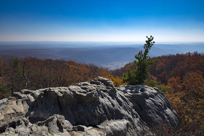
Black Mountain Trail; image by cumberlandtrail.org
Crossville Attractions:
Cumberland County Playhouse, a non-profit organization established in 1965 and governed by its volunteer board of directors, presents world premiere musicals, shows with a Tennessee flavor, Broadway favorites, drama and a concert series! Centrally Located in Crossville, Tennessee between Nashville, Knoxville and Chattanooga, the Cumberland County Playhouse is the prime performing arts resource in rural Tennessee and one of the South's major professional theaters.
With two full-time stages and a third seasonal stage, the Playhouse serves its state-wide audience with more than 450 performances and 1500 arts education classes annually and is the top indoor tourist attraction in the Cumberland Mountains.
Black Mountain Trail
Distance: 30+ miles
Rating: moderate to strenuous
Elevation: 800' to 2828'
Maps: USGS Quadrangles: Black Mtn, Roddy, Dorton, Ozone
Access: Take exit 329 off of I-40 at Crab Orchard (east of Crossville), drive south on the road that crosses I40 to Black Mountain (5 miles). Park at Owl Roost Gap (3.2 miles from I40) or at the FAA towers.
Map
This is a popular hiking and rock climbing area. Off-road vehicles frequent the area, and there is a maze of jeep roads and ATV trails, making navigation difficult. Much of the land is private, so obey signs.
A nice starter loop (6.5 miles) is to park at Owl Roost Gap (2320') (where a jeep road descends off to the east). From the Gap ride back down the pavement 0.3 miles and take the jeep road going west along the north face of Black Mountain. This face is covered with wild flowers in mid to late April. At mile 0.6 pass a jeep road descending right. At mile 1.3 pass a jeep road climbing left. At mile 1.9, the jeep road intersects the Cumberland Trail (white blazes) that has descended 1.2 miles from the mountain top. Turn right and go down the Cumberland Trail to the 4-way intersection at mile 2.1. Go left down the nice descent to the 6-way intersection (1930') at mile 2.7. Take the left (at "10 o'clock") and descend and cross a creek and visit Windless cave at mile 3.0 (1890') (picture, 54K). (A trail from the left at the creek crossing has descended 1.8 miles from the mountain top. Note that the cave is the drain for a large sink hole.) Continue climbing on past the cave, and at mile 4.9 you arrive at a clearing with lots of downed trees. Take the ATV track to the left and climb up to a 4-way intersection at mile 5.2. The road to the left goes back to the pavement, continue straight (east) to the intersection with Dug Hill Ridge Road at mile 5.3. You can turn left and climb 1.1 miles to the pavement (go right at the next intersection).
To extend the ride, turn right and zoom down Dug Hill Ridge to mile 6.9, where you take a sharp left and descend down to Sandy Creek and then push up the other side to a 4-way intersection in a clearing at mile 8.5 (1940'). The road to the right takes you toward Basin Rock/Falls and on to Whites Creek. Turn left and climb 1.7 miles back to the Gap, or go straight ahead and take a left in 0.8 miles at the next 4-way (1940'), and climb The Shinbone 1.1 miles to 2500'. At the top you have views to the North, bear left and descend back to the dirt road 0.1 miles from the Gap.
You can ride the single track from the towers through the crack in the cap rock and follow Cumberland Trail to Windless Cave. With a shuttle car east of White's Creek on Black Creek Road off of US27, you can ride 15 miles from Black Mtn through Dogwood and down the old stage road. You have to cross (wade/swim) White's Creek, so pick a dry time of the year. This is just a sampling of the trails of Black Mountain.
Catoosa Trail
Distance: 40+ miles
Rating: moderate
Elevation: 820' to 2340'
Maps: USGS Quadrangles: Lancing, Cardiff, Ozone, Herbertsburg, Fox Creek, Dorton, Harriman, Camp Austin. Maps, including the WMA map, are available at the Obed Park office in Wartburg (423-346-6294).
Access: Catoosa Rd west out of Wartburg (US 27), or Genesis Rd (TN 298) off of TN 62 west of Lancing
The area is usually closed February through March and at various times in the fall and spring for hunts. Contact the WMA manager (800-262-6704 or 931-456-2479) for current access information.
The Catoosa Wildlife Management Area occupies 80,000 acres on the Cumberland Plateau. The area is administered and owned by the Tennessee Wildlife Resources Agency, funded by hunters and fisherman. Catoosa is laced with gravel and dirt roads and some single track. Numerous whitewater streams (Obed -- National Wild & Scenic River, Emory, Clear Creek, Daddys Creek, Whites Creek, and Crab Orchard Creek) cut canyons and gorges through the sandstone. There are numerous spur trails to overlooks on the sandstone cliffs and a few loops.
TWRA's controversial "daylighting" of roads has reduced the quality of riding through the forests. To reduce road maintenance costs, TWRA is clearcutting the road ways in 75' wide swaths and putting down 2" rock on the secondary spurs. The pine beetle is also wreaking havoc with the remaining forest trails.
A nice 18.5 mile gravel loop starts at the Catoosa checking station winds around to Buck Switch then on up to the Bicolor checking station (2160') and then down to Island Creek and back to your starting point. (cumulative climb 2340')
At a 4-way about a mile west (elevation 1760') of Bicolor, you can also take a nice ATV track to the northeast 2.9 miles across Island Creek (1120') to the Catoosa checking station. At mile 1.9 (1460') at a 4-way, an old ATV track climbs to the "Virginia Pine Lot", 0.7 (1800') miles east of Bicolor. A TWRA spur also goes south 1.9 miles to the main gravel.
On Catoosa/Nemo Rd. (1850') just a mile east of the Buck Switch junction with the road to Daddy's Creek (or about 8 miles from Nemo Bridge), there is a road that leads north 0.5 miles to the Distance: 40+ miles
Rating: moderate
Elevation: 820' to 2340'
Maps: USGS Quadrangles: Lancing, Cardiff, Ozone, Herbertsburg, Fox Creek, Dorton, Harriman, Camp Austin. Maps, including the WMA map, are available at the Obed Park office in Wartburg (423-346-6294).
Access: Catoosa Rd west out of Wartburg (US 27), or Genesis Rd (TN 298) off of TN 62 west of Lancing
The area is usually closed February through March and at various times in the fall and spring for hunts. In 2000, the area is closed Sep. 30 - Oct 8, Oct 20-21, Nov 16-18, Nov 30-Dec 2, Dec 14-16, Jan 4-6. Contact the WMA manager (800-262-6704 or 931-456-2479) for current access information.
Description: The Catoosa Wildlife Management Area occupies 80,000 acres on the Cumberland Plateau. The area is administered and owned by the Tennessee Wildlife Resources Agency, funded by hunters and fisherman. Catoosa is laced with gravel and dirt roads and some single track. Numerous whitewater streams ( Obed -- National Wild & Scenic River, Emory, Clear Creek, Daddys Creek, Whites Creek, and Crab Orchard Creek) cut canyons and gorges through the sandstone. There are numerous spur trails to overlooks on the sandstone cliffs and a few loops.
TWRA's controversial "daylighting" of roads has reduced the "quality" of riding through the forests. To reduce road maintenance costs, TWRA is clearcutting the road ways in 75' wide swaths and putting down 2" rock on the secondary spurs. The pine beetle is also wreaking havoc with the remaining forest trails.
A nice 18.5 mile gravel loop starts at the Catoosa checking station winds around to Buck Switch then on up to the Bicolor checking station (2160') and then down to Island Creek and back to your starting point. (cumulative climb 2340')
At a 4-way about a mile west (elevation 1760') of Bicolor, you can also take a nice ATV track to the northeast 2.9 miles across Island Creek (1120') to the Catoosa checking station. At mile 1.9 (1460') at a 4-way, an old ATV track climbs to the "Virginia Pine Lot", 0.7 (1800') miles east of Bicolor. A TWRA spur also goes south 1.9 miles to the main gravel.
On Catoosa/Nemo Rd. (1850') just a mile east of the Buck Switch junction with the road to Daddy's Creek (or about 8 miles from Nemo Bridge), there is a road that leads north 0.5 miles to the Pilot Knob fire tower (2050'). Halfway up this road, an ATV track heads northeast 8.4 miles along Hatfield Mountain and descends steeply to the campground at Nemo bridge (860'), or you can take a right after 2.7 miles and exit back to Nemo Rd, or at mile 4.5 you can take a right and descend 3 miles to Nemo Rd (the gravel road just above the campground gravel road).
Distance:
40+ miles
Rating: moderate
Elevation: 820' to 2340'
Maps: USGS Quadrangles: Lancing, Cardiff, Ozone, Herbertsburg, Fox Creek, Dorton, Harriman, Camp Austin. Maps, including the WMA map, are available at the Obed Park office in Wartburg (423-346-6294).
Access: Catoosa Rd west out of Wartburg (US 27), or Genesis Rd (TN 298) off of TN 62 west of Lancing
The area is usually closed February through March and at various times in the fall and spring for hunts. In 2000, the area is closed Sep. 30 - Oct 8, Oct 20-21, Nov 16-18, Nov 30-Dec 2, Dec 14-16, Jan 4-6. Contact the WMA manager (800-262-6704 or 931-456-2479) for current access information.
Description: The Catoosa Wildlife Management Area occupies 80,000 acres on the Cumberland Plateau. The area is administered and owned by the Tennessee Wildlife Resources Agency, funded by hunters and fisherman. Catoosa is laced with gravel and dirt roads and some single track. Numerous whitewater streams ( Obed -- National Wild & Scenic River, Emory, Clear Creek, Daddys Creek, Whites Creek, and Crab Orchard Creek) cut canyons and gorges through the sandstone. There are numerous spur trails to overlooks on the sandstone cliffs and a few loops.
TWRA's controversial "daylighting" of roads has reduced the "quality" of riding through the forests. To reduce road maintenance costs, TWRA is clearcutting the road ways in 75' wide swaths and putting down 2" rock on the secondary spurs. The pine beetle is also wreaking havoc with the remaining forest trails.
A nice 18.5 mile gravel loop starts at the Catoosa checking station winds around to Buck Switch then on up to the Bicolor checking station (2160') and then down to Island Creek and back to your starting point. (cumulative climb 2340')
At a 4-way about a mile west (elevation 1760') of Bicolor, you can also take a nice ATV track to the northeast 2.9 miles across Island Creek (1120') to the Catoosa checking station. At mile 1.9 (1460') at a 4-way, an old ATV track climbs to the "Virginia Pine Lot", 0.7 (1800') miles east of Bicolor. A TWRA spur also goes south 1.9 miles to the main gravel.
On Catoosa/Nemo Rd. (1850') just a mile east of the Buck Switch junction with the road to Daddy's Creek (or about 8 miles from Nemo Bridge), there is a road that leads north 0.5 miles to the Pilot Knob fire tower (2050'). Halfway up this road, an ATV track heads northeast 8.4 miles along Hatfield Mountain and descends steeply to the campground at Nemo bridge (860'), or you can take a right after 2.7 miles and exit back to Nemo Rd, or at mile 4.5 you can take a right and descend 3 miles to Nemo Rd (the gravel road just above the campground gravel road).
At mile 1.5 along Hatfield Mountain, a left descends (gnarly) .7 miles and then heads west up Turkey Creek. At mile 3, you cross Turkey Creek and climb back to the main gravel at mile 4.6. Mile 6.7 brings you back to the parking area with a cumulative climb of 830' for the loop.
There are several ATV trails southeast of the gravel between Island Creek and the Bicolor checking station, some interconnecting with the jeep roads to Camp Austin. Clark Cemetery ATV trail descends 2.2 miles from Camp Austin Road to White Oak Rd., then west 4.5 miles to Bicolor, then east 2.8 miles to close the 10 mile loop.
To the west, there is a nice 8 mile loop along the east side of Otter Creek, and loops in the vicinity of Peavine Mountain. (2050'). Halfway up this road, an ATV track heads northeast 8.4 miles along Hatfield Mountain and descends steeply to the campground at Nemo bridge (860'), or you can take a right after 2.7 miles and exit back to Nemo Rd, or at mile 4.5 you can take a right and descend 3 miles to Nemo Rd (the gravel road just above the campground gravel road).
At mile 1.5 along Hatfield Mountain, a left descends (gnarly) .7 miles and then heads west up Turkey Creek. At mile 3, you cross Turkey Creek and climb back to the main gravel at mile 4.6. Mile 6.7 brings you back to the parking area with a cumulative climb of 830' for the loop.
There are several ATV trails southeast of the gravel between Island Creek and the Bicolor checking station, some interconnecting with the jeep roads to Camp Austin. Clark Cemetery ATV trail descends 2.2 miles from Camp Austin road to White Oak Rd., then west 4.5 miles to Bicolor, then east 2.8 miles to close the 10 mile loop.
To the west, there is a nice 8 mile loop along the east side of Otter Creek, and loops in the vicinity of Peavine Mountain.
Devil's Breakfast Table Trail
This portion of the Obed W.S.R. Segment, built by Morgan County Regional Correctional Facility and CTC volunteers, covers 8.0 miles one-way and currently terminates deep inside Catoosa W.M.A. at the end of the abandoned dinky rail line. From the Devil's Breakfast Table Trailhead, the trail winds on the right side of the road for 0.2 miles before crossing the road and dipping down below the bluff. You now find yourself in Daddy's Creek gorge, rich with rhododendron, and for the next mile you will walk under sheer bluffs and among the rock steps laid down by the trail builders. Once again, the given name "a trail of a thousand steps" becomes apparent here. At 1.2 miles you will rise out of the canyon through an Appalachian cove forest overlooking a ninety-foot sheer bluff cut by a cascading stream. Cross the stream and proceed a short distance to the aptly-named Blueberry Bluff side trail, with views of Daddy's gorge. Return to the main trail and continue north 0.75 miles a side trail to Morgan's Overlook, offering views of Daddy's to the north. Rejoin the main trail and travel 0.4 miles to the Rain House, so named for the shelter it offered the builders of this trail on many a day. Then the trail works down in the gorge of Daddy's Creek as it winds its way steadily north to join the Obed River and connect in with the Nemo Bridge Trail.
To reach this trailhead take I40 to exit 320 Peavine Road and head north 1.8 miles to a left on Firetower Road. Take Firetower Road 14.7 miles to Daddy's Creek and the Devil's Breakfast Table parking area across the bridge on the right. Park and walk NE 40 yards on the road to the trailhead.
Homesteads Tower stands in the center of the Homestead Community as the most visual landmark of this area. It is constructed of native Crab Orchard Stone and became known as the "Showplace of the New Deal."
Nemo Bridge Trail
Trail is closed to hikers during Fall hunts. This portion of the Obed W.S.R. Segment, within the Obed and Emory River gorges, incorporates the Obed's 2.5 mile Nemo Trail and an additional 2.5 mile segment built by the Cumberland Trail Conference, Tennessee Trails Association, and Breakaway Volunteers, giving a total one-way distance of 5.0 miles. The initial 2.5 miles is rated moderate, and the final 2.5 miles strenuous, as you find yourself hiking down into the Obed basin. From the Nemo Trailhead the hiker is exposed to rising bluffs and glimpses of the Emory and Obed Rivers. As you rise to the top of the gorge among a dryer forest of oak and hickory, you will soon walk on the tailings of an old strip mine, indicative of the history of the Cumberland Mountains. Notice and explore the pools of water tapped by these old tailing piles -- what aquatic creatures have benefited from these pools? At 2.5 miles the trail continues on across old Alley Ford Road and continues 1.5 miles into and out of the Obed Gorge to the rewarding Break Bluff, a dramatic overlook of the Obed Gorge. On your way to the bluff notice and give thanks to the trail builders' talent, particularly when you reach the door, a 40-foot drop from the bluff into the Obed Gorge below. The next 1.0 miles follows the bluff.
To reach the Nemo Trailhead, take I40 to exit 347 and go north on Hwy. 27 to Wartburg. Follow the signs in downtown Wartburg to the Nemo/Catoosa Rd., and travel 7 miles to the Obed W.S.R. bridge crossing, cross and take the first right down into the Rock Creek Camp Area and the Nemo Trailhead.
How to get to the trail:
Take I-40 East to exit 347, then turn right and drive towards Harriman. Go north through Harriman on Hwy 27 to Wartburg. In Wartburg, Take Main Street to Maiden St, then turn left onto Maiden. Turn right off of Maiden onto Catoosa Rd. Drive 5.8 miles down Catoosa road to the Nemo Bridge, after crossing the bridge the road to the Trailhead is .2 miles on the right, in the campground.
The Parking Lot is Straight ahead. There is a road to the right of the parking lot that goes to another campground. The Nemo Trailhead is 50 ft down this road, to the left.
Crossville Hotels >>
|
|
|


